SuitAbility Tour
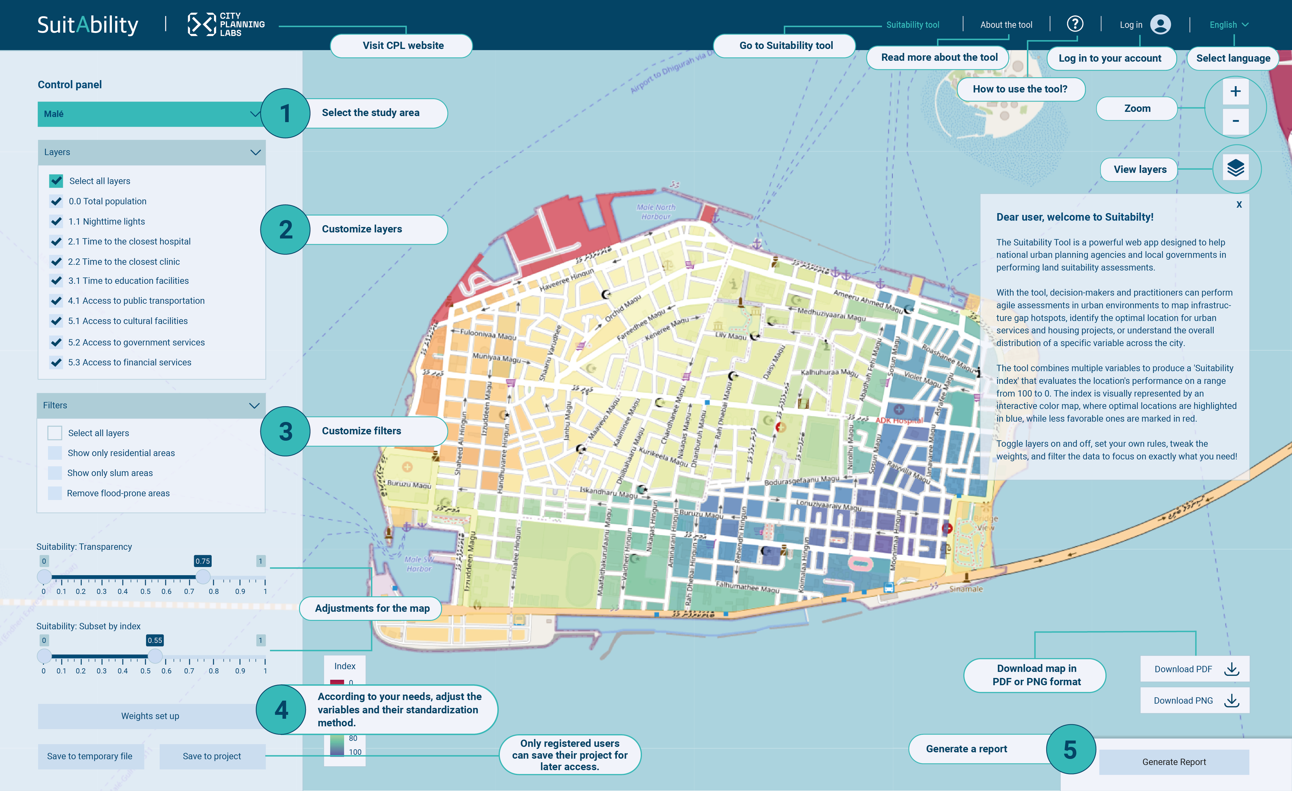
The Suitability Tool is a powerful web app designed to help national urban planning agencies and local governments in performing land suitability assessments.
With the tool, decision-makers and practitioners can perform agile assessments in urban environments to map infrastructure gap hotspots, identify the optimal location for urban services and housing projects, or understand the overall distribution of a specific variable across the city.
The tool combines multiple variables to produce a 'Suitability index' that evaluates the location's performance on a range from 100 to 0. The index is visually represented by an interactive color map, where optimal locations are highlighted in blue, while less favorable ones are marked in red.
Toggle layers on and off, set your own rules, tweak the weights, and filter the data to focus on exactly what you need!
| Project name | Last modified | Description | Options |
|---|---|---|---|
| Ephemeral adaptation of public spaces around health facilities | Nov. 25, 2025, 9:51 p.m. | In Mexico City, public spaces surrounding hospitals function as informal waiting zones where patients and caregivers endure long, precarious waits. This research analyzes the social and religious groups that respond to these conditions, revealing how their activities relate to the public space. | |
| urban informalities | Nov. 25, 2025, 3:07 a.m. | Lead project of the urban informalities cluster, part of the sustainable territorial development research group at the School of Architecture, Art, and Design at Tecnológico de Monterrey. | |
| Feasibility of a public rental housing model | Nov. 11, 2025, 12:26 p.m. | This research analyzes the feasibility of a public rental housing model as an alternative to improve access to adequate housing for young women in vulnerable situations in Mexico City. | |
| Kanya - Mombasa | July 8, 2025, 9:57 p.m. | This is a proof of concept for an agile adaptation for Mombasa. The team used the following Google Colab Notebook to create this dataset: https://colab.research.google.com/drive/1nzNBcVi28lmQoEaEYO3CgwEuUTwE_Ivm | |
| Kanya - Nairobi | July 8, 2025, 9:39 p.m. | This is a proof of concept for an agile adaptation for Nairobi. The team used the following Google Colab Notebook to create this dataset: https://colab.research.google.com/drive/1nzNBcVi28lmQoEaEYO3CgwEuUTwE_Ivm | |
| Mozambique Tete | April 17, 2025, 12:20 a.m. | ADE collaboration for spatial development - Proof of concept | |
| Mozambique Maputo | April 17, 2025, 12:15 a.m. | ADE collaboration for spatial development - Proof of concept | |
| Mozambique Nacala | April 17, 2025, 12:14 a.m. | ADE collaboration for spatial development - Proof of concept | |
| Mozambique Nampula | April 17, 2025, 12:10 a.m. | ADE collaboration for spatial development - Proof of concept | |
| Vulnerabilidad Xochimilco | Feb. 21, 2025, 3:39 a.m. | Vulnerabilidad Xochimilco | |
| Vulnerabilidad Benito Juárez | Feb. 19, 2025, 5:34 a.m. | Vulnerabilidad Benito Juárez | |
| Colombo | Feb. 13, 2025, 3:40 p.m. | Colombo with OMS | |
| Vulnerabilidad Tlalpan | Feb. 12, 2025, 5:43 a.m. | Vulnerabilidad Tlalpan | |
| Vulnerabilidad Coyoacán | Feb. 12, 2025, 2:18 a.m. | Vulnerabilidad Coyoacán | |
| Baku | Feb. 10, 2025, 8:20 p.m. | Baku, Azerbaijan. Data from OSM 2025. | |
| Movilidad AMG | Jan. 30, 2025, 11:43 p.m. | Información de Movilidad en el Área Metropolitana de Guadalajara | |
| Ejército Ote. Iztapalapa | Jan. 30, 2025, 11:44 p.m. | Correlación entre entornos peatonales, paradas de transporte público y percepción de inseguridad en el nororiente de Iztapalapa | |
| Tijuana CADi TEC | Jan. 30, 2025, 11:44 p.m. | Ejercicio ST para CADi | |
| pruba 1 maluisa | Jan. 30, 2025, 11:45 p.m. | prueba para ver ejemplos de csv y geojason | |
| Erdenet | June 27, 2024, 2:28 p.m. | Identifying infrastructure gaps in Erdenet | |
| Malé | June 27, 2024, 2:28 p.m. | This is a default description for Is Malé Island a 15-minute city? |